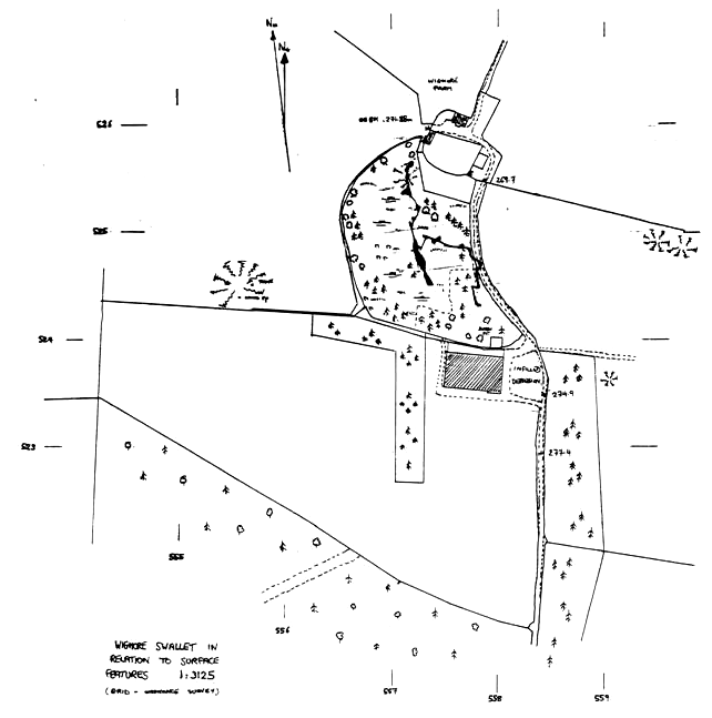
Wigmore Swallet
Notes on the survey
and some thoughts on further work
by Trevor Hughes
From:- Belfry Bulletin No 462, December 1991
INTRODUCTION: Digging at Wigmore has been a
long, hard slog, thousands of man hours have been spent breaking
rocks and hauling spoil. The Bosch drill has come of age and the
digging team are now quite skilled in shothole placement. A
superb draught throughout the duration of the dig held out great
promise. Once the dig had well and truly 'gone' it was
time to clear away skips, sacks and shovels and dust off the
compass, 'clino' and Fibron tape.
THE SURVEY: The field data for the survey was
collected on four separate trips, June - Sept '91, keeping
pace with the rapid progress of discovery and exploration. A
calibrated Sunto compass and clinometer and 30m. Fibron tape were
used to collect data to BCRA grade 5d. Leapfrog compass readings
were taken in the Marl section of the cave in case of any
ore-body induced magnetic deviation but highly consistent
readings and the confined nature of the dug passages meant that
forward bearings only became the norm, a system I maintained
throughout the larger conglomerate passages.
The 1991 survey was commenced on 5th June at the entry point
of Christmas Crawl into Santa's Grotto, following hot on the
heels of the initial breakthrough on 3rd June. A seven hour
marathon session by Pete McNab (Snab), Chris Castle and the
author surveyed to the deepest point available the temporarily
blocked Hernia Pot and the large high level chamber discovered
that day and named Drake's Hall in honour of Bob Drake
(W.C.C.), a keen digger, whose tragic death had occurred twelve
months previously. A provisional plot was available on 10th June
having coupled the new work to Dave Irwin's survey of April
1978 (see BB No. 371 p.15/16) having metricised the earlier
drawing (plotted originally at 1:120 horizontally and 1:75
vertically).
The next session on 28th July by Steve Redwood, Mark Simms
(S.M.C.C.) and the author surveyed the narrow rifts and inlets
below Hernia Pot. The deepest point available was the bottom of
the cross-joint pot, so far only descended by J'Rat, at
-73.2m. The survey stopped at the tight U-tube, now christened
Butch's Arse in recognition of the names verbal gaff in the
Hunter's one night about the likelihood of Wigmore ever
'going' as a dig.
The time consuming rift-widening beyond Butch's Arse
continued until mid-August when the two superb pitches and
streamway were discovered. The survey of this section as far as
the first upstream sump was carried out by the author, Tony
Jarratt, Rich Blake and Max Midlen on 9th Sept. The stream
section was a delight to survey, 8-10m. survey legs being the
norm, the passage width averaging 2m. and 1.5m. high in the silt
floored phreatic tube of the Upper Yeo.
Work commitments prevented me from joining the fourth trip but
the field work was ably completed by the boys from the black
stuff, Vince Simmonds, Graham Johnson and Rich Blake on 15th
Sept., when the upstream sumps I and II and the final streamway
section to upstream sump III was surveyed. The two short sumps
presented little problem if the air space survey stations were
carefully positioned.
The Upper Yeo streamway is bounded upstream and downstream by
sumps which will require some concerted effort to pass due to the
atrocious visibility. Dany Bradshaw has penetrated the downstream
sump for 35m. at approx. 3m. depth (but see the survey for the
latest. Dany passed the sump to a short length of passage with a
dry inlet on his very next dive - Ed) and Keith Savory has
achieved 6m. of upstream progress at 4m. depth. The zero vis'
conditions of these sumps means that producing an accurate survey
through them will be somewhat difficult. Radio location is the
obvious answer here: a fix at each end of the sump, established
on the surface will enable co-ordinate differences to be plotted
onto the master survey, coupled with a measured sump length to
minimize error.
The master survey has been drawn up at 1:200 well filling the
AO sheet. The plan fits well but the projected elevation of the
streamway runs off the sheet and will be drawn displaced on the
finished article.
FACTS, FIGURATION and FANTASY: Wigmore
Swallet has a passage length of 474m. so far surveyed if the
terminal sumps are included, of this 402m. has been entered for
the first time in 1991. The deepest point of the cave, 93.5m.
below the entrance shaft cap, is the bottom of the 3m. deep
downstream sump pool. The drop in water level between upstream
sump III and the downstream sump is only 1.25m. suggesting that
in winter flow conditions a considerable proportion of the Upper
Yeo may sump. The hydraulic gradient of this section is 1.09%
compared with the 2.06% mean gradient of Tor Hole to Wigmore and
1.6% Wigmore to Cheddar Risings (These figures assume straight
line flow and are indicative only).
The inlet downstream of upstream sump III is speculated to be
seepage water from the slurry tank adjacent to the large cowshed
but this cannot be confirmed, it does however smell somewhat
foul. The source(s) of the main streamway need to be located by
hydrographic tracing, possible sites being Red Quar Swallet, the
adjacent His Lordship's Hole both taking water in mid-Sept.
and, of course, Tor Hole.
There are other large depressions to the north of Stock Hill
which should be investigated. A large depression to the south of
Red Quar Swallet is dry in summer but may repay digging
especially if "Tuska Tactics" are used to expose the
underlying rock strata.
In the space of nine short months Wigmore has been transformed
from a squalid dig into a big league cave a demanding trip with
plenty to offer tight rifts and squeezes, superb airy pitches and
climbs, spacious chambers, a large streamway and open ends. By my
reckoning Wigmore is Mendips 13th deepest cave although this
figure could be eclipsed when the Twin Titties Swallet survey
appears.
With so much depth potential remaining (the downstream sump
surface is 171.4m. A.O.D.) Wigmore could soon be in the top ten.
If a connection to Gough's could be made a system with 265m.
vertical range would result.
Perhaps it's time to get the shovels out again?
|